Paste text
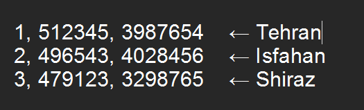
Paste rows as "1, 512345, 3987654" (No, x, y) or just "512345 3987654" or "12321,12312" (x, y — the No column is optional, commas/tabs/spaces all work).
Load Excel file
Supports .xlsx, .xls and .csv. We find the No / x / y columns automatically.
فایل اکسل را اینجا رها کنید
یا کلیک کنید
استخراج از متن عکس یا pdf
تصویر بزرگ دارید؟ ابتدا ناحیه جدول را برش بزنید. OCR تصویر شما را میخواند — موتورهای پولی نقاط را سمت سرور استخراج میکنند.
عکس یا PDF را اینجا رها کنید
یا برای انتخاب کلیک کنید
Load GIS file
فایل GPX، KML یا KMZ حاوی نقاط را بارگذاری کنید؛ مختصات WGS84 آن با زون UTM انتخابشده به x/y تبدیل میشود.
فایل GPX، KML یا KMZ را اینجا رها کنید
یا کلیک کنید
2 · Review & edit points
Fix anything, add rows, and validate before building the polygon.
3 · Map preview
Points converted UTM → WGS84 and drawn in order. Toggle how they connect.
4 · Export
Download everything you used to make in ArcMap — right from the browser.
Excel (.xlsx)
First row merged: "UTM WGS84 zone 39N", then No / x / y — exactly what ArcMap's Add XY Data expects.
KML (.kml)
Polygon Placemark in WGS84 lon,lat — opens in Google Earth, QGIS, ArcGIS Earth.
KMZ (.kmz)
The KML, zipped — the compact format you used to save from ArcMap.
GeoJSON (bonus)
Developer-friendly format — handy for web maps and future Supabase storage.
GPX (.gpx)
A track through your points — opens in Garmin, Google Maps, Strava and most GPS apps.